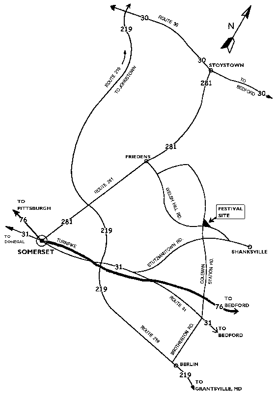
|
From
Pittsburgh & West…
Take the turnpike to
Somerset exit # 110.
Follow signs to route 31 east.
Take route 31 east 3 miles to Stutzmantown Road.
Turn left onto Stutzmantown Road and follow 5 miles to Coleman Station
Road. (At Flight 93 Memorial Chapel.)
Turn left onto Coleman Station Road and go 1 mile to stop sign. (next
to campground)
Go straight through intersection and the festival grounds entrances are
on the right
From Bedford & East…
Take the turnpike to
Somerset exit # 110 and follow directions above from Somerset.
-OR-
Take route 30 west to Stoystown.
Take route 281 south 4 miles to Friedens.
Turn left onto Welsh Hill Road and follow straight 3 miles to the
second Coleman Station Road intersection. (NOTE: Ignore the FIRST Coleman Station Road intersection that you come
to on Welsh Hill Road...while this will get you there, the road becomes
very steep and rough.)
Turn left onto Coleman Station Road and festival grounds entrances are
on the right.
-OR-
Take route 31 west to
Brotherton.
Turn right onto Coleman Station Road and follow straight 5 miles to
festival site.
From Johnstown &
North…
Take route 219 south
to route 30.
Follow route 30 east to Stoystown and follow directions above from
Stoystown.
From Grantsville &
South…
Take route 219 north
through Berlin.
Just at the north edge of Berlin, turn right onto Brotherton Road and
follow to route 31 where by crossing route 31, Brotherton Road turns
into Coleman Station Road.
Cross route 31 and follow Coleman Station Road 5 miles to festival site.
Watch for FESTIVAL signs
located at selected intersections.
|